Ground-Penetrating Radar: Reading Reflections Beneath the Surface
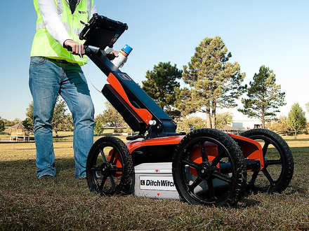
The ground can hide layers, cavities, and other features that are difficult to inspect from above. Ground-penetrating radar, or GPR, sends electromagnetic energy into the subsurface and records returning signals. It offers a way to investigate without beginning with extensive excavation.
What produces a reflection?
USGS reports describe GPR as a transmitting-and-receiving method that responds to the electromagnetic properties of subsurface materials. Contrasts between materials can produce reflected signals. The record can then be interpreted as a profile of features along a survey path.
A reflection is not automatically an identification. The instrument measures a signal associated with an interface or object; an interpreter must connect that signal with the setting and the question being investigated. Supporting information is therefore valuable.
Why ground conditions matter
USGS research explains that electrically conductive materials attenuate radar energy. Clay-rich sediments or saline porewater can severely reduce useful penetration. Better performance in a low-conductivity setting should not be treated as evidence that the same depth can be achieved everywhere.
Frequency also creates a tradeoff. USGS’s discussion of sand-bar surveys notes that lower-frequency signals can reduce attenuation, while limiting the ability to resolve small features. Choosing equipment involves balancing the size and depth of the target with site conditions.
A hypothetical survey
Imagine researchers studying the arrangement of shallow sediment layers beside a river. They could plan survey lines, document position, record the radar profiles, and compare interpretations with independent geological observations. The goal would be a supported explanation of the subsurface rather than a visually impressive image alone.
This example reflects the kind of hydrological and geological work described by USGS, but it is not a claim about a particular field site. A project should state what it is trying to detect and what the data can reasonably establish.
Interpreting a useful result
A radar image can contain reflections from more than the feature of interest. Multiple reflections, scattering, and changes in material properties can complicate the record. USGS’s study of surface-water surveys discusses several such limitations and explains how complementary methods can help.
A credible report should distinguish a clear observation from an uncertain interpretation. It should also state areas where the signal did not support a useful conclusion. Absence of a visible reflection does not automatically prove absence of every possible feature.
Summary
Ground-penetrating radar investigates the subsurface through electromagnetic reflections. It can provide useful profiles when conditions and targets are suitable. Its value depends on site conductivity, equipment choice, survey design, and interpretation supported by knowledge of the surrounding materials.
Works Cited
U.S. Geological Survey. “Application of Ground-Penetrating Radar Methods in Determining Hydrogeologic Conditions in a Karst Area, West-Central Florida.” n.d. Accessed 10 Oct. 2026.
U.S. Geological Survey. “The Internal Structure of Sand Bars on the Colorado River, Grand Canyon, as Determined by Ground-Penetrating Radar: Introduction.” 2001. Accessed 10 Oct. 2026.
Haeni, F. P. U.S. Geological Survey. “Use of Ground-Penetrating Radar and Continuous Seismic-Reflection Profiling on Surface-Water Bodies in Environmental and Engineering Studies.” 1 Apr. 1996. Accessed 10 Oct. 2026.
The Charles Machine Works. “Ground Penetrating Radar in use.” Wikimedia Commons, 1 October 2010. Image. CC BY-SA 2.0. Accessed 10 Oct. 2026.
Ground-penetrating radar equipment in use. Image: The Charles Machine Works; CC BY-SA 2.0.